 |
Tuesday Night Poster Session at the LPSC 2016.
I might be in there somewhere...
Image credit: Lunar and Planetary Institute. |
|
|
This year's Lunar and Planetary Science Conference (LPSC) was another success. I again went as an independent researcher, but this time I was also looking for employment opportunities. I got a few leads, which I will follow up in the next few weeks.
I also rejoined the official LPSC microblogging crew. Some of you may have followed my short posts on Google+ during the conference. As usual, I am reproducing my entire complement of LPSC microblogs, plus appropriate links (if available), here on the Planetary Geo Log. Again, the intent is for you to digest a few small nuggets at a time. I hope to write up some of these in future blogs, so keep an eye out. If you would like to learn more about any of the posted topics, please feel free to make a request in the comments.
Sunday March 20, 2016
1) Hello folks. I am at the Lunar and Planetary Science Conference again this year and will be microblogging on Google+. I hope you enjoy my observations of the conference.
(
http://www.hou.usra.edu/meetings/lpsc2016/)
2) Attended this year's #Microsymposium57 before #LPSC2016. I'll be posting some
highlights......
(
http://www.planetary.brown.edu/html_pages/micro57.htm)
3) David Paige has found that there are more volatiles in low latitude craters at the lunar poles, because those craters catch the poleward-migrating volatiles before they can reach the high latitudes of the poles.
#Microsymposium57 before #LPSC2016.
4) Barb Cohen is looking for "operationally useful amounts of water" on the Moon, which means large quantities. She proposes this can be done using cube satellites. #Microsymposium57 before #LPSC2016.
5) Mahesh Anand tells us that ESA considers the Moon to be the primary target for human exploration after the ISS. #Microsymposium57 before # LPSC2016.
6) Tony Colaprete and Jen Heldmann told us about the proposed Resource Prospector mission. It consists of a rover that will take measurements and samples at several locations on the lunar pole. #Microsymposium57 before #LPSC.
Monday March 21, 2016
1) Catherine Johnson shows that the magnetic field on Mercury is strongest in the Caloris basin and the magnetic field is at least as old as the Caloris basin.
(
http://www.hou.usra.edu/meetings/lpsc2016/pdf/1391.pdf)
2) L. Hood noted that you need a long-standing magnetic field to explain the magnetic signatures seen at Caloris and Sobkou basins on Mercury. So, Mercury would have had a magnetic dynamo at the time these basins formed.
(
http://www.hou.usra.edu/meetings/lpsc2016/pdf/1301.pdf)
3) The models of P. James suggest that the lithosphere of Mercurry is 32 (+/-15) km thick.
(
http://www.hou.usra.edu/meetings/lpsc2016/pdf/1992.pdf)
4) C. Fasset shows that crater degradation on Mercury happens much faster than on the Moon.
(
http://www.hou.usra.edu/meetings/lpsc2016/pdf/1046.pdf)
5) Robbie Herrick noted that Mercury has more craters <10 km in diameter than would be expected for the number of craters >10 km in diameter. This would be due to a larger number of secondaries. If so, the oldest surfaces on Mercury could be 100 m.y. younger than previously estimated.
(
http://www.hou.usra.edu/meetings/lpsc2016/pdf/2766.pdf)
6) Congratulations to last year's Dwornik student award winners:
Robert Jacobson - U Tennessee,
Hanna Susorney - John Hopkins,
Johnathan Oulton - Florida State,
Hank Cole - Colorado School of Mines.
7) Alan Stern reported on the New Horizons mission results so far. Although the flyby of Pluto is complete, only half of the data has been transmitted, because lower transmission rates were selected to keep costs down. The other half of the data is still to come. What additional exciting things will we learn about Pluto?
(
PDF Presentation of Alan Stern's Talk)
(
Video of Alan Stern's Talk)
8) Pluto has 4 small satellites in addition to Charon. The outer-most, Hydra, rotates 100 times about its axis for each orbit around Pluto. It's quite mesmorizing in this animation that Alan Stern showed.
(
Animation of Pluto's Satellite's Orbits)
Comment on Google+: Wow. Any particular reason for that? (spin:orbit resonances?)
My reply: No, they're not quite sure. Just sat in on a talk by S. Porter, where they discussed the small satellites. All have retrograde rotations, which is odd, so they suspect this may be related to some kind of tidal state.
9) Pluto's large, bright, smooth plane, called Sputnik Planum, is thought to be an ancient impact basin that is filled with nitrogen ice. This ice shows evidence of glacial flows at the northern edges according to Alan Stern.
10) Using GRAIL Gravity data from the Moon, Maria Zuber showed that cryptomaria (hidden mare deposits) in the Schiller-Zucchius basin do NOT extend to a depth of 10 km. This is not a surprising result, but it's good to have a confirmation of this.
(
http://www.hou.usra.edu/meetings/lpsc2016/pdf/2105.pdf)
11) Tony Colaprete reported on LADEE data for the thin lunar atmosphere, or exosphere. Titanium and magnesium concentrations in the exosphere are somewhat correlated with mafic deposits on the surface and aluminum deposits are somewhat corelated with surface highlands, though the surface compositions cannot completely explain the exosphere compositions.
(
http://www.hou.usra.edu/meetings/lpsc2016/pdf/2635.pdf)
12) The Pluto/New Horizons research articles in Science are all open access!! Enjoy...
(
http://science.sciencemag.org/content/351/6279)
13) S. Porter tells us that the moons of Pluto are in extremely stable orbits and their surfaces (as far as we can tell with the limited available data) are cratered and old. So, these moons are not new or ephemeral objects, but have been orbiting around Pluto for a long time.
(
http://www.hou.usra.edu/meetings/lpsc2016/pdf/2390.pdf)
14) NASA Night at #LPSC2016. NASA is looking for community input on how we use NASA data. Foreign input is also welcome. There will be a link posted on the LPSC webpage with instructions on how to submit your input. I will update this microblog post with the link as soon as it goes up.
Instructions for submitting input can be found at: (
http://science.nasa.gov/researchers/sara/grant-solicitations/nasa-request-information-assessing-planetary-science-communitys-use-planetary-science-division-facilities/)
15) NASA Night at #LPSC2016. Cosmoquest was mentioned as one of the organizations that won an Education and Public Outreach grant this year. Congratulations #Cosmoquest!
(
https://cosmoquest.org/)
16) NASA Night at #LPSC2016. Jim Green tells us that the NASA planetary science budget got $270 million more than was requested this year!!
Total budget is $1.63 billion.
17) NASA Night at #LPSC2016. This was Jim Green's closing slide for questions.
18)
Really enjoyed meeting old friends and new at the Students Reception.
Tuesday March 22, 2016
1) Jeff Plescia told us that impact melt flows on the Moon show evidence of multiple pulses of material from the same impact.
(
http://www.hou.usra.edu/meetings/lpsc2016/pdf/2585.pdf)
2) Jason Cook talked about the distribution of non-volatiles on Pluto. Apparently this means water, which I think of as a volatile. But water does not act like a volatile on Pluto, because of the extremely cold temperatures. Jason finds that water is widely destributed on Pluto, predominantly as fine particles.
(
http://www.hou.usra.edu/meetings/lpsc2016/pdf/2296.pdf)
3) Misha Kreslavsky found large-scale dendritic patterns, with a topographic range of 20 meters, in parts of the lunar maria.
(
http://www.hou.usra.edu/meetings/lpsc2016/pdf/1331.pdf)
4) Lisa Gaddis showed that M3 data can be used to identify volcanic pyroclastic deposits on the Moon.
(
http://www.hou.usra.edu/meetings/lpsc2016/pdf/2065.pdf)
5) Tom Giguere suggests that the floor of Gassendi crater, a floor-fractured crater on the north-west shore of Mare Humorum on the Moon, shows evidence of drained lava lakes.
(
http://www.hou.usra.edu/meetings/lpsc2016/pdf/1884.pdf)
6) Carl Allen used Diviner data, collected during a lunar eclipse, to show that pyroclastic deposits in the Aristarchus region of the Moon cool faster than other materials in sinuous rills, maria, or mare rays. The thermal inertia of pyroclastic material must, therefore, be lower, possibly due to a much finer grain size.
(
http://www.hou.usra.edu/meetings/lpsc2016/pdf/1309.pdf)
7) Carolyn van der Bogert showed that the Dark Mantle Deposits of Taurus Littrow are actually older
than the surrounding maria, even though they look younger. This is because small craters in the dark mantle deposit are in saturation and have experienced preferential degredation, while the small craters in the nearby maria are still in production, resulting in more craters
at that size.
(
http://www.hou.usra.edu/meetings/lpsc2016/pdf/1616.pdf)
8) Tuesday poster sessions were such a whirlwind, I didn't get a chance to microblog about anything.
9) 30th annual Hawaii Party was it's usual fun. Really enjoyed chatting with Tom Giguere and Steve Ruff.
Wednesday March 23, 2016
1) Daniel Moriarty and Makiko Ohtake presented back-to-back competing interpretations for the interior of the South Pole-Aitken basin on the Moon. I confess, I am confused....
(
http://www.hou.usra.edu/meetings/lpsc2016/pdf/1735.pdf)
(
http://www.hou.usra.edu/meetings/lpsc2016/pdf/1414.pdf)
2) Noah Petro presented work that supports the presence of cryptomare deposits in the Bhabha region of South Pole-Aitken basin on the Moon. During the question period, Apollo 17 astronaut Jack Schmidtt noted that one of the flat-floored irregular craters in the region may not be a flooded impact crater, but rather a volcanic caldera related to the cryptomare volcanism period.
(
http://www.hou.usra.edu/meetings/lpsc2016/pdf/2669.pdf)
3) Paul Spudis identified a number of units around the edges of Mare Crisium on the Moon. These units poke through, and so pre-date, the mare material of the basin. Paul suggests that these may be remnants of the Crisium impact melt sheet and so would make good targets for future sample-return missions.
(
http://www.hou.usra.edu/meetings/lpsc2016/pdf/1463.pdf)
4) Based on low-angle impact experiments, Pete Schultz proposes that so-called "double impacts", which have been identified in GRAIL gravity data from the Moon, may actually be due to a single low-angle impact. What happens is the approaching bolide hits the surface at an oblique angle, causing the top of the bolide to decapitate and hit the surface in a second location down-range, producing what looks like a double impact.
(
http://www.hou.usra.edu/meetings/lpsc2016/pdf/2931.pdf)
5) Shared from Stuart Robbins.
Lisa Gaddis: NASA’s Cartography & Imaging Sciences Node contains >850TB of data, growing at ~120TB/yr.
(
http://www.hou.usra.edu/meetings/lpsc2016/pdf/2281.pdf)
6) Just uploaded the electronic version of my #LPSC2016 poster. You can see it here...
(
http://www.hou.usra.edu/meetings/lpsc2016/eposter/2948.pdf)
7) Pamela Gay told us about the exciting funding developments happening for the #Cosmoquest project during our Cosmoquest community meeting at #LPSC2016.
8) At the #Cosmoquest community meeting (during #LPSC2016), Andrea Jones encouraged us to spread the word about International Observe the Moon Night, happening this year on Oct. 8, 2016. Now is the time to start planning your event. Don't forget to register your local event, whether it's a big museum function or a small neighbourhood get together, so InOMN can highlight how global this celebration truly is! Instructions on how to get involved can be found under the Get Involved tab on the web link below.
(
http://observethemoonnight.org/)
 |
Frustum
Image credit: Wikipedia.
|
|
|
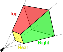
9) New Vocabulary Word from R. Beyer's talk at #LPSC2016.
Frustum: A diagram illustrating the angle a camera is pointing towards the target surface.
10) Planetary Spatial Infrastructure session at #LPSC2016 was very interesting. Best quote has got to be "Cartography is important to cartography." This means that Cartography, as the manipulation of digital data so that it can be presented in a map, is important to Cartography, the process of creating maps.
(
http://www.hou.usra.edu/meetings/lpsc2016/pdf/sess453.pdf)
11) LEAG Networking Session at #LPSC2016. A group of young scientists are gathered around Apollo astronaut Jack Schmidtt, soaking up his wisdom.
12) Smart people tend to be more prone to unintentional bias. They tend to feel they are immune to this bias, because they are smart. So recognize that you have biases, know what they are, and work to overcome them. #WomenInPlanetaryScience and #LPSC2016.
13) Being self-aware of your own biases and working on those is not enough. The culture and institutions in the community need to be changed too, to help overcome this bias problem. Senior and mid-career members, who are less vulnerable, need to take the initiative in this regard. #WomenInPlanetaryScience evening at #LPSC2016.
14) Discussion section of the #WomenInPlanetaryScience evening at #LPSC2016. was great.
Thursday March 24, 2016
1) Systems engineering is ensuring that you don't design misunderstandings into your system. #NextGenWorkshop Scientists and Engineers: Learning to Work Together at #LPSC2016.
(
Video about system engineering, recommended by the presenter, Lee Graham )
2) Think of mission requirements as dollars in a different form. You want the minimum necessary requirements to cover the scope and objectives of your entire mission, no more and no less. #NextGenWorkshop Scientists an Engineers: Learning to Work Together at #LPSC2016.
3) Totally amazed by the interesting people who stopped by my unconventional planetary poster about using financial modeling techniques for identifying basalt spectra.
(
http://www.hou.usra.edu/meetings/lpsc2016/pdf/2948.pdf)
(
http://www.hou.usra.edu/meetings/lpsc2016/eposter/2948.pdf)
4) The annual Arizona Party was fun, but I was too beat from my poster session to take advantage of the dance floor and DJ. Does anyone know if there was much dancing this year?
Friday March 25, 2016
1) Michael Nayak found that magnetic data from the South Pole-Aitken basin suggests the existence of several new magnetic paleo-poles on the Moon, which had not been previously identified.
(
http://www.hou.usra.edu/meetings/lpsc2016/pdf/2506.pdf)
2) Lon Hood suggested that the absence of magnetization on the rims of large lunar impact basins may be due to their being erased by subsequent volcanic flooding. However, Mark Wieczorek pointed out that his earlier work shows that mare layers cool too quickly for their heat to be able to erase the magnetic signature.
(
http://www.hou.usra.edu/meetings/lpsc2016/pdf/1303.pdf)
3) Rona Oran used simulations to model the behaviour of the lunar magnetic field during large-scale impact events. Her work shows that the magnetic field is increased all over the Moon during an impact event, not just at the antipode. However this increase is too small to explain observed magnetizations, thus supporting a stable core dynamo as their source.
(
http://www.hou.usra.edu/meetings/lpsc2016/pdf/3057.pdf)
4) Mark Wieczorek gave a fascinating talk about the depth of lunar magnetization. Almost the entire Moon is magnetized and most of it has a deep origin. This means that impact magnetization, which only affects the surface, is not the dominant magnetizing process on the Moon. Similarly, volcanic intrusions cannot be used to explain magnetism on the far side, where volcanism is very limited. Therefore, most of the magnetization seen on the Moon must have been accumulated during slow cooling of the primordial crust in the presence of a stable dynamo. Magnetization of the farside crust would have been locked in by 230 million years after the formation of the Moon, so the dynamo must have been in place by then. This is even earlier than the oldest magnetized samples we have from the Moon, which have been dated at 4.25 billion years old (~250 million years after the formation of the Moon).
(
http://www.hou.usra.edu/meetings/lpsc2016/pdf/2288.pdf)
5) D.A. Patthoff mapped two populations of ridges on Enceladus, one old and one recent. Based on these, the following tectonic history was proposed: compression of the crust associated with its formation, followed by a long tectonically quiet period, culminating in a recent period (<100 m.y.) of compression possibly associated with thickening of the crust due to cooling of the underlying ocean. What is not known is what are the implications of this history or the evolution of life and how long before the ocean completely freezes over.
(
http://www.hou.usra.edu/meetings/lpsc2016/pdf/1772.pdf)
6) Mike Bland proposes that the grooved terrain of Ganymede is formed when magmatic intrusions heat the overlying crust. This allows convection in the intrusion to push the overlying crust and bunch it up (like a table cloth) to form sets of parallel grooves.
(
http://www.hou.usra.edu/meetings/lpsc2016/pdf/1287.pdf)
7) Audience request for some Game of Thrones names on Charon.
8) We have reached the end of #LPSC2016. Thank you so much for letting me bombard you with my observations. I hope you enjoyed it, I know I did. Until next year....


